You are here
User guide for the Belgian LifeWatch e-Lab
Through this interactive section of the LifeWatch.be portal users can upload their own data using a standard data format, and choose from several web services, models and applications to process the data.
1. HOW TO USE THE WEB SERVICES
2. DESCRIPTION DATA FORMAT
3. DESCRIPTION WEB SERVICES
1. HOW TO USE THE WEB SERVICES
1. Upload your file
To upload your own data files to the e-Lab, you will require a log-in and password. You can obtain these freely by registering here.
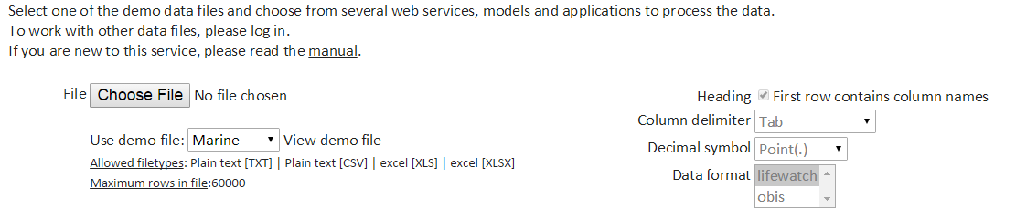
Note: without log-in and password you can use a marine or terrestrial demo file to discover the functionalities of the e-Lab.
Prepare your data file for upload. Allowed file types: Plain text [TXT], Plain text [CSV], Excel [XLS] and Excel [XLSX].
Note: All web services (except one, see further) require the uploaded data to be in the standard LifeWatch data format, based on and compatible with the OBIS Schema and Darwin Core. In SECTION 2 of this user guide you can find a description of this LifeWatch data format, some examples, and an overview of the required fields for every web service. The only exception is the "Check OBIS file" web service, which requires the uploaded data to be in the OBIS Schema format, instead of the LifeWatch data format.
Click on "Browse" or "Choose file" (depending on your browser) to upload your file. This will open the file explorer on your PC. Select your file.
Heading: use the flag box to indicate whether your first row contains the column names or not.
Column delimiter: select the relevant column delimiter: Tab, Semicolon (;), Comma (,) or Vertical bar (|)
Decimal symbol: select the relevant decimal symbol: Comma (,) or Point (.)
Data format: select "lifewatch" for all web services (except for "Check OBIS file"); only select "obis" for the "Check OBIS file" web service (see above).
2. Select web services
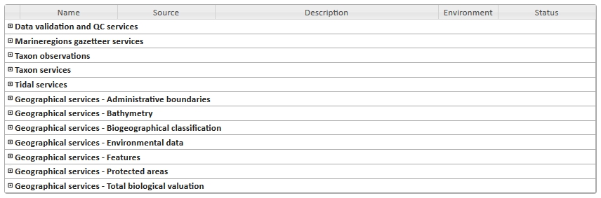
Choose the desired web services. Clicking on the "+" next to each category will list the individual web services. In this overview every web service is provided with a short description, source, whether the service is applicable to marine or terrestrial data, and its status. A more extensive description of the web services can be found in SECTION 3 of this user guide.
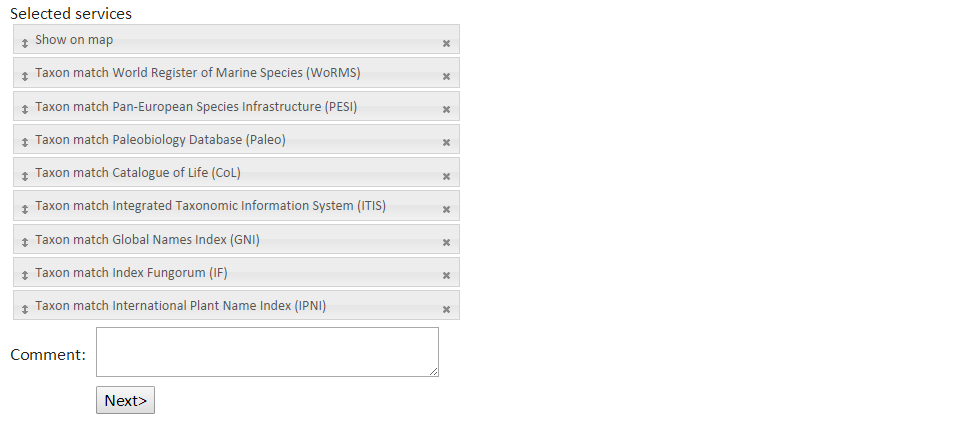
3. Verify order, change order if necessary and run
The selected web services are shown in the lower part of the screen. In case of multiple web services selected, the order can be changed by dragging the grey bars with the arrows on the left.
4. Preview screen
When clicking on "Next", you are redirected to the preview screen. Select the column names from the data format term that correspond to your columns. In the example below a list with coordinates (data file = 2 columns containing latitude and longitude) was uploaded and the requested data service was "Bathymetry Southern Bight of the North Sea". The options "Latitude" and "Longitude" were selected from the data format term.
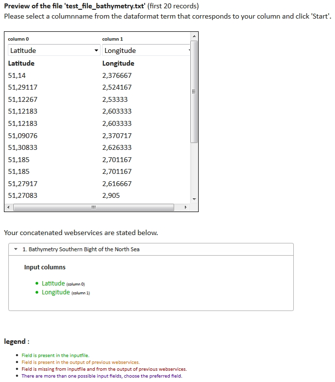
In the lower section of the preview screen, you can find information about duplicate or missing fields per requested web service.
Duplicate fields can occur in case of concatenated web services: the field is present in the original uploaded data file (the input file), and the field is also generated by a previous web service. Choose the correct field.
5. Results
Click "Start". The following message appears:
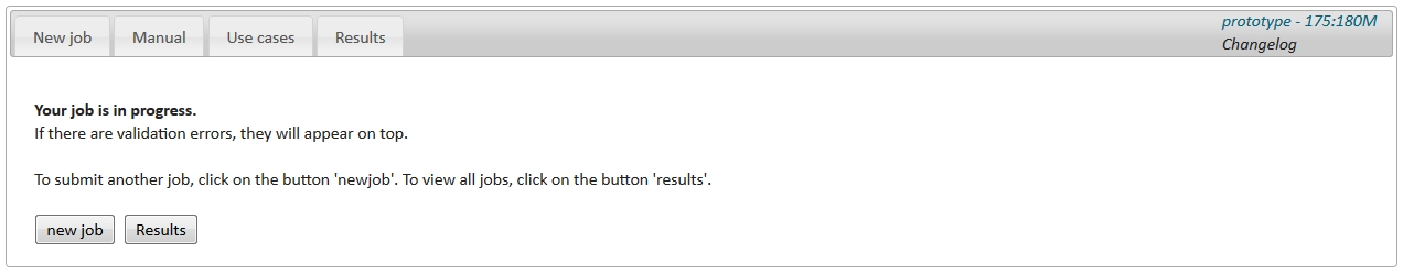
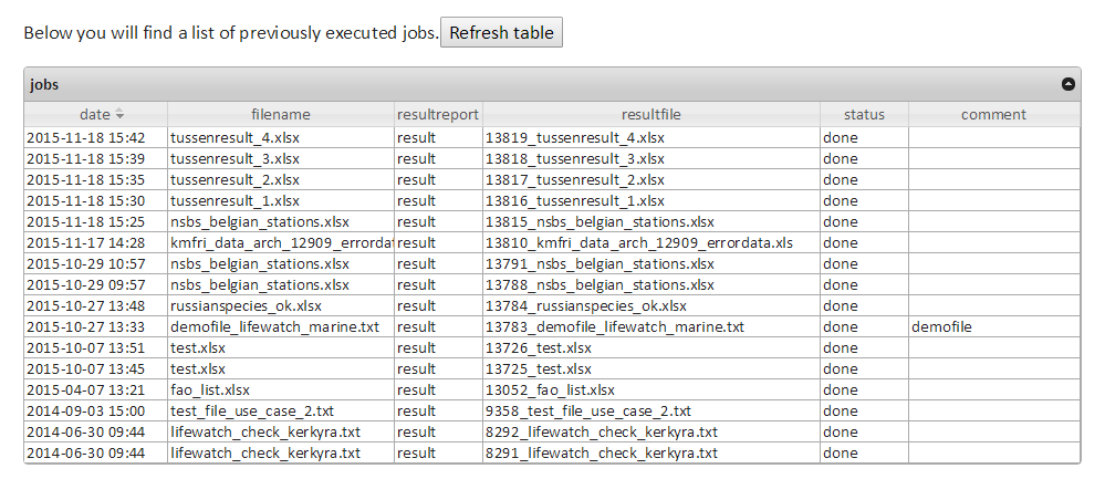
Your results will appear at the top of the results table. The "filename" is the original data file you uploaded. Within the "resultfile" additional columns have been added to the original file, containing information derived from the requested data services. The "resultreport" gives an overview of the requested web services and any errors that might have occurred during the process. These files are linked to your account and can be downloaded for further analysis at any time.
[Top page]DataFormat
2. DESCRIPTION DATA FORMAT [Top page]
The LifeWatch.be portal uses a specific standard data format which is based on the OBIS Schema and the Darwin Core Version 2 standard.
This LifeWatch data format is a tab delimited (.txt) ASCII file and can contain the following fields: Survey, LocationID, Longitude, Latitude, WKTFootprint, EventID, SamplingProtocol, EventDate, MinimumDepth, MaximumDepth, FieldNumber, SampleSize, ScientificName, ScientificNameID, Sex, LifeStage, ObservedIndividualCount and AssociatedSequences. An extensive description of each field can be found here.
Not all fields are required for every web service. The table below gives an overview of the required fields for the individual web services:
| Web service category | Web service name | Required fields in the data format |
| Data validation and QC services | Show on map | Latitude, Longitude |
| Data format validation | Latitude, Longitude, EventDate | |
| Check OBIS file | ||
|
Marineregions gazetteer services |
Get lat-long by mrgid | LocationID |
| Get lat-long by name | Location | |
| Get gazetteer name by lat-long | Latitude, Longitude | |
| Get lat-long by accepted name | Location | |
| Taxon observations | Number of observations of a marine taxon | ScientificNameID |
| Number of observations in a 1000m radius around a point | Latitude, Longitude | |
| Taxon list of a certain region | LocationID | |
| Taxon services | Get AphiaID World Register of Marine Species (WoRMS) | ScientificName |
| Reverse taxon match by ITIS TSN | ScientificNameID (ITIS TSN) | |
| Reverse taxon match by AphiaID | ScientificNameID (AphiaID) | |
| Taxon match | ScientificName | |
| Tidal services | Calculate tidal reduction | Latitude, Longitude, EventDate |
| Administrative boundaries | EMODnet regions | Latitude, Longitude |
| Exclusive Economic Zones (EEZ) | Latitude, Longitude | |
| ICES Ecoregions | Latitude, Longitude | |
| IHO Sea Areas | Latitude, Longitude | |
| Marine Regions (intersect EEZ and IHO) | Latitude, Longitude | |
| World Countries | Latitude, Longitude | |
| FAO Fishing Areas | Latitude, Longitude | |
| Bathymetry | Bathymetry Southern Bight of the North Sea | Latitude, Longitude |
| GEBCO bathymetrie | Latitude, Longitude | |
| MARSPEC: global marine bathymetrie (Resolution: 30 arc seconds) | Latitude, Longitude | |
| Biogeographical classification | Longhurst Biogeographical Provinces | Latitude, Longitude |
| Marine Realms of the World | Latitude, Longitude | |
| Marine Ecoregions of the World | Latitude, Longitude | |
| Marine Provinces of the World | Latitude, Longitude | |
| Large Marine Ecosystems of the World | Latitude, Longitude | |
| Environmental data | Cloud Cover (maximum) | Latitude, Longitude |
| Chlorophyll A (mean) | Latitude, Longitude | |
| Chlorophyll A (maximum) | Latitude, Longitude | |
| Sea Surface Temperature (maximum) | Latitude, Longitude | |
| Silicate (mean) | Latitude, Longitude | |
| Diffuse Attenuation (maximum) | Latitude, Longitude | |
| Cloud Cover (mean) | Latitude, Longitude | |
| Diffuse Attenuation (minimum) | Latitude, Longitude | |
| Photosynthetically Available Radiation (mean) | Latitude, Longitude | |
| Sea Surface Temperature (mean) | Latitude, Longitude | |
| pH (mean) | Latitude, Longitude | |
| Photosynthetically Available Radiation (maximum) | Latitude, Longitude | |
| Nitrate (mean) | Latitude, Longitude | |
| Chlorophyll A (range) | Latitude, Longitude | |
| Calcite Concentration (mean) | Latitude, Longitude | |
| Cloud Cover (minimum) | Latitude, Longitude | |
| Phosphate (mean) | Latitude, Longitude | |
| Dissolved Oxygen (mean) | Latitude, Longitude | |
| Salinity (mean) | Latitude, Longitude | |
| Sea Surface Temperature (range) | Latitude, Longitude | |
| Sea Surface Temperature (minimum) | Latitude, Longitude | |
| Chlorophyll A (minimum) | Latitude, Longitude | |
| Diffuse Attenuation (mean) | Latitude, Longitude | |
| Features | Shoals (Belgian Continental Shelf) | Latitude, Longitude |
| Protected areas | Flemish Ecological Network | Latitude, Longitude |
| Total biological valuation | Marine Biological Valuation (Total) | Latitude, Longitude |
| Terrestrial Biological Valuation (v22) | Latitude, Longitude |
Some example ASCII files can be found here:
- Example file for Taxon match WoRMS
- Example file for geographic services
- Example file for tidal reduction
[Top page]DataFormat
3. DESCRIPTION WEB SERVICES [Top page]
The web services can also be used in a concatenated way, where the output of the first web service is the input for the next web service. This is demonstrated in the Use cases.
Please note: currently only three concatenated web services are allowed, i.e. currently you can only select 3 web services in 1 job.
Data validation and QC services:
-
Show on map: This service generates a map based on Latitude and Longitude in the uploaded data file. The resulting map is available in the result report.
-
Data format validation: The LifeWatch portal uses a specific standard data format based on Darwin Core and the OBIS Schema (see above). This service checks if the uploaded data file matches this standard LifeWatch data format.
-
Check OBIS file: This service checks if the uploaded data file matches the OBIS Schema (mandatory and missing fields), checks the format of the date and coordinates and checks if the observation points are located at sea or on land. This service also performs a WoRMS taxon match.
Marineregions gazetteer services:
-
Get lat-long by mrgid: Returns the latitude and longitude of the centroid and the preferred gazetteer name of a Marine Regions ID (MRGID), based on the MRGID in the uploaded data file.
-
Get lat-long by name: Returns the latitude, longitude, matched name and the Marine Regions ID (MRGID) of a given gazetteer name in the uploaded data file.
-
Get gazetteer name by lat-long: Returns the Marine Regions place name and the Marine Regions ID (MRGID) of the bounding box (radius 3) based on Latitude and Longitude in the uploaded data file.
-
Get lat-long by accepted name: Returns the latitude, longitude, accepted name and the Marine Regions ID (MRGID) of a given gazetteer name in the uploaded data file.
Taxon observations:
-
Number of observations of a marine taxon: Returns all observation points (latitude and longitude) in the Ocean Biodiversity Information System (OBIS) for a specific species, based on the ScientificNameID in the uploaded data file.
-
Number of observations in a 1000m radius around a point: Returns the number of observations in the Ocean Biodiversity Information System (OBIS) of taxon in a radius of 1000 meter around a point, based on Latitude and Longitude in the uploaded data file.
-
Taxon list of a certain region: Returns a taxon list based on observations from the Ocean Biodiversity Information System (OBIS) for a certain region, based on the Marine Regions ID (MRGID) in the uploaded data file.
Taxon services:
- Get AphiaID World Register of Marine Species (WoRMS): Returns the (first) exact matching AphiaID for a given taxon name, based on the ScientificName in the uploaded data file.
- Reverse taxon match by ITIS TSN: Returns the Aphia record (scientific name, taxonomic status, etc.) based on the Taxonomic Serial Number (TSN) of the Integrated Taxonomic Information System (ITIS) in the uploaded data file.
- Reverse taxon match by AphiaID: Returns the Aphia record (scientific name, taxonomic status, etc.) based on the AphiaID of the World Register of Marine Species (WoRMS) in the uploaded data file.
- Taxon match: Matches your taxon list with the World Register of Marine Species (WoRMS), Catalogue of Life (CoL), the Integrated Taxonomic Information System (ITIS), the Pan-European Species directories Infrastructure (PESI), the International Plant Names Index (IPNI), the Global Names Index (GNI), Index Fungorum (IF), and the Paleobiology Database (PaleoDB), based on the ScientificName in the uploaded data file.
Tidal services:
-
Calculate tidal reduction: Calculates tidal heights in NAP (Normaal Amsterdams Peil), GLLWS (Gemiddeld Laag LaagWater bij Springtij), and TAW (Tweede Algemene Waterpassing) based on Latitude, Longitude and EventDate in the uploaded data file. The calculations are based on the M2 tidal reduction algorithm and the water levels measured by the monitoring network Flemish Banks.
Geographical services - Administrative boundaries:
-
These web services return the name and code of administrative boundaries, such as EMODnet regions, Exclusive Economic Zones (EEZ), ICES Ecoregions, IHO Sea Areas, Intersect of the EEZ and IHO (Marine Regions), World Countries, and FAO Fishing Areas, based on Latitude and Longitude in the uploaded data file.
Geographical services - Bathymetry:
-
Bathymetry Southern Bight of the North Sea: Returns the bathymetry for points in the Southern Bight of the North Sea (from the "Limited Atlas of the Belgian Part of the North Sea"), based on Latitude and Longitude in the uploaded data file.
-
GEBCO bathymetrie: returns the bathymetry from the General Bathymetric Chart of the Oceans (GEBCO), based on Latitude and Longitude in the uploaded data file.
-
MARSPEC: global marine bathymetrie (Resolution: 30 arc seconds): Returns the global marine bathymetry with a resolution of 30 arc seconds from the Ocean Climate Layers for Marine Spatial Ecology (MARSPEC), based on Latitude and Longitude in the uploaded data file.
Geographical services - Biogeographical classification:
-
These web services return the name and code of biogeographical areas, such as Longhurst Biogeographical Provinces, Marine Realms of the World, Marine Ecoregions of the World, Marine Provinces of the World, and Large Marine Ecosystems of the World, based on Latitude and Longitude in the uploaded data file.
Geographical services - Environmental data:
-
These web services return environmental data from Bio-ORACLE (Ocean Rasters for Analysis of Climate and Environment): a global environmental dataset for marine species distribution modeling, based on Latitude and Longitude in the uploaded data file. Available parameters include: Sea Surface Temperature (minimum, maximum, mean, range), Salinity (mean), Chlorophyll-a (minimum, maximum, mean, range), Photosynthetically Available Radiation (minimum, mean), pH (mean), Calcite Concentration (mean), Dissolved Oxygen (mean), Silicate (mean), Nitrate (mean), Phosphate (mean), Diffuse Attenuation (minimum, maximum, mean), and Cloud Cover (minimum, maximum, mean).
Geographical services - Features:
-
Shoals (Belgian Continental Shelf): Indicates if a given location in the Belgian Continental Shelf is situated on a shoal, based on Latitude and Longitude in the uploaded data file, and gives the name and group of the shoal.
Geographical services - Protected areas:
-
Flemish Ecological Network: Indicates if a given location is situated within the Flemish Ecological Network, based on Latitude and Longitude in the uploaded data file, and gives the type and name of the VEN-area. The Flemish Ecological Network (VEN) is a selection of valuable and sensitive natural areas in Flanders. The Flemish government gives priority to nature conservation and nature development in these areas.
Geographical services - Total biological valuation:
-
Marine Biological Valuation (total): Returns the total marine biological value of a location in the Belgian Continental Shelf, based on Latitude and Longitude in the uploaded data file and the Biological Valuation Map for the Belgian Continental Shelf (BWZee) produced in 2007.
-
Terrestrial Biological Valuation (v22): Returns the terrestrial biological value of a location in the Flemish Region, based on Latitude and Longitude in the uploaded data file and the Biological Valuation Map (version22). The Biological Valuation Map is a uniform field-driven survey of the land cover and vegetation in the Flemish Region.