You are here
X marks the spot: type localities in WoRMS and how they might reveal new insights in species discovery mysteries
Publication date: January 26th 2023
The dictionary describes a type locality as “the geographical location where a type specimen was originally found”. So, for each species, the first discovery location is known, which is documented in its original description. In addition, the author(s) document in which collection (museum, institute) they have deposited the type species. This latter piece of information can also be documented in WoRMS, but is not in the scope of this story.
How are type localities documented in WoRMS?
As the type locality is considered as extremely relevant information to link with a species name, the Aphia infrastructure allows for detailed documentation of this information, either in a very structured or a more flexible way. Ideally, the type locality is documented with its exact latitude and longitude, allowing straightforward plotting of these coordinates on a map. In many cases, however, the latitude/longitude values are not available, and the type locality is a verbatim description of the location where the specimen was collected. This description can be very detailed or very broad. Examples include descriptions like “Bay between Taboga and Taboguilla, Taboga Island, Panama, Pacific Ocean” or “Australia: Port Phillip Bay (Victoria), mouth of Werribee River” to more general descriptions such as Scotia Sea, North-Atlantic or Antarctic.
Type locality information in WoRMS can be captured in several layers of detail. In a perfect situation, the latitude/longitude values are provided in the original description. Exact coordinates allow an easy and unambiguous visualisation of the type locality on the WoRMS distribution maps. In cases where no coordinates are provided, which is for a large majority of older species descriptions, we still motivate editors to document the available information. Occasionally, the latitude/longitude values can easily be (approximately) derived from a provided map or a very detailed description of the sampling location. When this is not possible, in many cases the information can be reformulated as ‘type locality contained in [place name X]’. It is in these latter cases when actual coordinates are missing that the link with Marine Regions becomes very important. Marine Regions is a standard list of marine georeferenced place names and areas. It improves access and clarity of the different geographic marine names such as seas, sandbanks, ridges and bays and displays unequivocally the boundaries of marine biogeographic or managerial marine areas. Just as with WoRMS, Marine Regions is managed at the Flanders Marine Institute (VLIZ), which makes links and collaborations between both systems relatively easy and straightforward.
What do we already know?
Within WoRMS, a little over 24,500 species, or roughly 10%, have their type locality documented as actual latitude/longitude values. On a monthly basis, these type localities are shared with the Ocean Biodiversity Information System (OBIS) as a dedicated ‘WoRMS type locality’ dataset, that will soon also be available at the Global Biodiversity Information System (GBIF).
At a very first glance, this map shows a lot of type localities along coastlines. Formulating conclusions based on this would be too preliminary, however, as this represents only 10% of the accepted marine species documented in WoRMS.
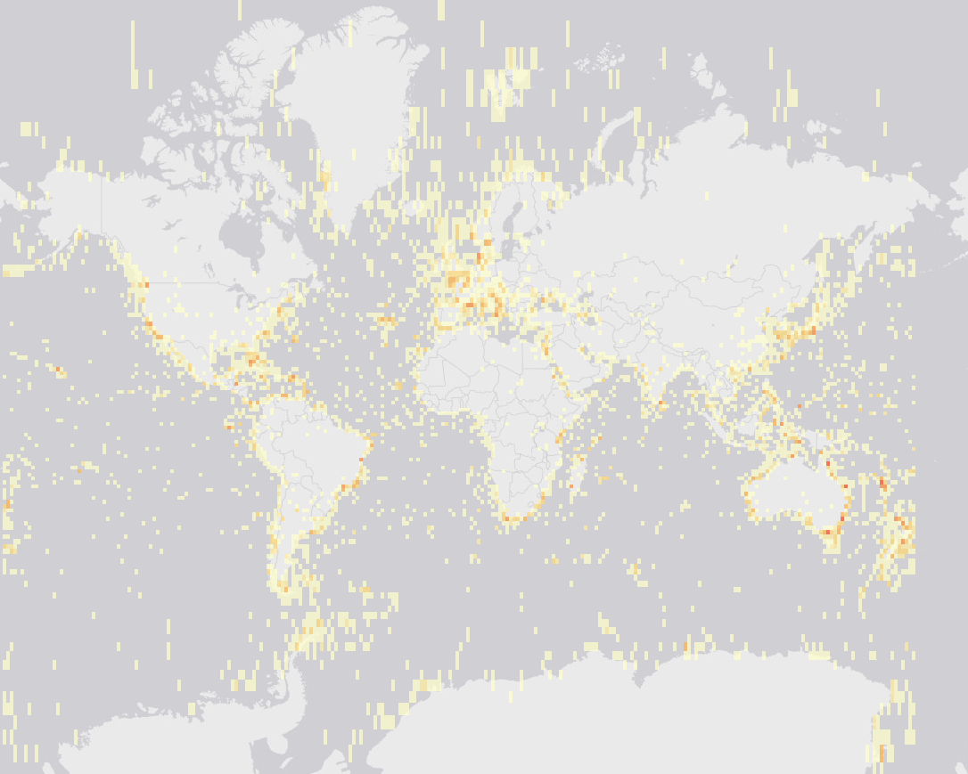
Figure: WoRMS type locality data documented with latitude/longitude, available in OBIS as the dataset “Type locality distributions from the World Register of Marine Species”. https://www.obis.org/dataset/b74b429a-4052-4f5b-bff3-fe0b5a2e8669
All distributions added to WoRMS are based on literature or expert knowledge, which distinguishes the distribution information in WoRMS from, e.g., the point location data derived from samples in the Ocean Biodiversity Information System (OBIS) and the Global Biodiversity Information Facility (GBIF). Although the distribution information in WoRMS and OBIS/GBIF has a different origin, both systems can benefit from each other on this level. Combining distribution information from WoRMS and OBIS allows identification of gaps and possible errors, as you would expect that the distribution information from both systems is more or less aligned with each other, and not completely contradictory.
Filling the type locality gap…
Documenting the type locality of each species is high on the priority list of the WoRMS Steering Committee. For many species, this entails diving into the original description and retrieving this information, either with the documented latitude/longitude or extracting the type locality in as much detail as possible from the general description of the sampling location. Because we are dealing with over 241,000 accepted marine species, this is by no means a trivial task!
The Data Management Team will evaluate this year how interns and students could contribute to tackling this gap, approaching the challenge most likely group-wise (family - order - class), so they can complete a small well-delineated part of this huge task, and perhaps, especially for interns, also look at the documented data in a meaningful way in the framework of their studies.
The relevance of filling the gap: why bother about type localities?
You might wonder why we target the documentation of type locality information as a priority? Well, this is largely because this information is so strongly linked to the actual species description, but also, at least from the DMT perspective, out of curiosity!
Have you ever wondered what the ‘species discovery hotspot(s)’ in our oceans might be, or whether there might still be actual ‘blank spots’ in our oceans, from where we have not yet documented any species in WoRMS? Or what about the historical traces: can ‘packages’ of species discoveries be clearly linked to (historical) expeditions or events, or have certain areas been very well explored within certain time-frames, but less or more in others?
Documenting and analysing these type localities can provide an answer to these questions. Also, these answers can either confirm some general thoughts or beliefs on where species have been and still are being discovered, or the results might just surprise us…
Contact
WoRMS Data Management Team - info@marinespecies.org
Image credits
Pirate treasure map by santiago silver
Acknowledgements:
This celebration and series of news messages initiated by the Data Management Team (DMT) would not have been possible without the collaboration of the WoRMS Steering Committee (SC) & voluntary contributions by many of the WoRMS editors.
The work of the DMT and many WoRMS-DMT-related activities are supported by LifeWatch Belgium, part of the E-Science European LifeWatch Infrastructure for Biodiversity and Ecosystem Research. LifeWatch is a distributed virtual laboratory, which is used for different aspects of biodiversity research. The Species Information Backbone of LifeWatch aims at bringing together taxonomic and species-related data and at filling the gaps in our knowledge. In addition, it gives support to taxonomic experts by providing them logistic and financial support for the organization of meetings and workshops related to expanding the content and enhancing the quality of taxonomic databases.
WoRMS – as ABC WoRMS – is an endorsed action under the UN Ocean Decade.
Note: as is the case for previous stories and their highlighted examples, many more examples are available within WoRMS. The highlighted examples are either well-known to the Data Management Team through close interactions with the related editor-groups or through discussions within the Steering Committee. It is by no means the intention of the DMT to favour any group or species over another. The names of all species are equally important to be documented within WoRMS.