Latest news

-
Sevenfold increase in stinging weever fish observed by SeaWatch-B 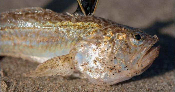
Sevenfold increase in stinging weever fish observed by SeaWatch-B
Between April and late June this year, weever fish counts were seven times higher than during the same period in 2024, according to SeaWatch-B, the citizen science project of the Flanders Marine Institute (VLIZ) under the LifeWatch Belgium Programme. -
Awardees for the 2025 WoRMS Achievement & Early Career Researcher Award known 
Awardees for the 2025 WoRMS Achievement & Early Career Researcher Award known
This year, Sammy De Grave has been honored with the WoRMS Achievement Award, and the WoRMS Early Career Researcher Award goes to Sávio Gabriel Gomes Pereira. -
Noise pollution in the North Sea 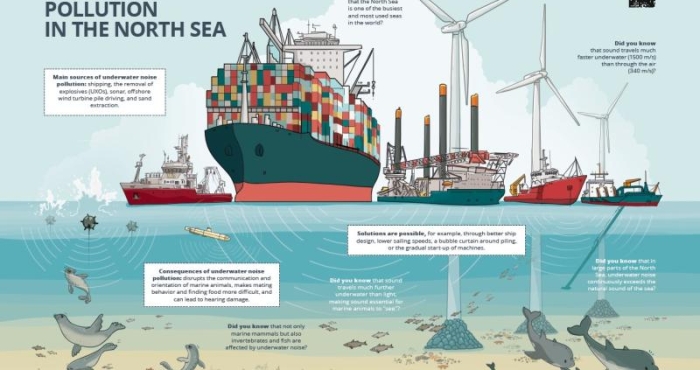
Noise pollution in the North Sea
The North Sea is one of the busiest seas in the world. All this human activity creates a lot of noise underwater. This can have harmful consequences for marine mammals and other organisms in our sea. Fortunately, measures exist to limit noise pollution. The Marine Environment Service (FOD Public Health) and DG Shipping (FOD Mobility), with the support of LifeWatch VLIZ, collaborated on a campaign to raise awareness about underwater noise pollution among the wider public. -
Old cockles and record number of shells at the eighth edition of the Big Seashell Survey 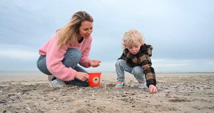
Old cockles and record number of shells at the eighth edition of the Big Seashell Survey
The eighth edition of the Big Seashell Survey was a record-breaking event. No fewer than 3,500 participants scoured 400 km of coastline in northern France, Belgium, and the Netherlands, collecting and identifying nearly 150,000 shells from 72 different species. This year, the differences between the three countries were less pronounced, with the cut trough shell ranking as the most frequently found species across all regions. The Atlantic jackknife clam, the banded wedge shell, and the common cockle consistently appeared in the top five. A one-time focus on the cockle in Belgium revealed that most of these shells originated in a distant past, with only a handful of live populations remaining in the shallow continental North Sea. -
Applications for the Ocean Census Species Discovery Awards 2025 are open 
Applications for the Ocean Census Species Discovery Awards 2025 are open
Thanks to the contribution of The Nippon Foundation, the Ocean Census is offering financial awards of $5,000 to $20,000 to support marine species discovery around the world. -
IMARPE presents the Peruvian Register of Marine Species platform 
IMARPE presents the Peruvian Register of Marine Species platform
This verified database groups the marine species recorded from Peru. -
WoRMS press release: Ten remarkable new marine species from 2024 
WoRMS press release: Ten remarkable new marine species from 2024
As for previous years, the World Register of Marine Species (WoRMS) has again released its annual list of the top-ten marine species described by researchers during the past year to coincide with World Taxonomist Appreciation Day on March 19th! -
Call for taxonomy projects to describe deep-sea species - One Thousand Reasons Edition 2025 
Call for taxonomy projects to describe deep-sea species - One Thousand Reasons Edition 2025
The "One Thousand Reasons" campaign just launched its second open call (Edition 2025) for taxonomy projects to describe deep-sea species.The ultimate goal of the International Seabed Authority (ISA) is to generate a lasting legacy in deep ocean sciences: the description of at least 1,000 species new to science in areas beyond national jurisdictions by 2030. Expressions of interest can be submitted by 15 April 2025. -
WoRMS Philanthropy Grants 2024 
WoRMS Philanthropy Grants 2024
In 2024, the VLIZ Philanthropy program awarded four grants to help WoRMS editors enhance the completeness of the World Register of Marine Species (WoRMS). These efforts led to nearly 9,000 edits and additions to WoRMS and its sub-registers. -
Return of the twaite shad to the Scheldt River After a Century-Long Absence 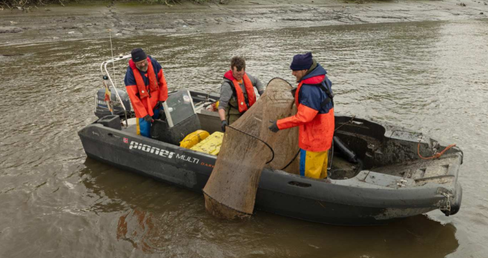
Return of the twaite shad to the Scheldt River After a Century-Long Absence
The twaite shad, a migratory fish that once disappeared from the Scheldt River due to pollution, has made a remarkable return in the past decade. Known locally as the “May fish,” the twaite shadspawns in the river between late April and early May. Researchers from the Institute for Nature and Forest Research (INBO) have been studying the species since its return in 2014, using LifeWatch Belgium acoustic telemetry and data loggers to track the fish’s movements and habits.