Latest news

-
A Taxon-Match tool for AlgaeBase, based on the WoRMS Taxon Match 
A Taxon-Match tool for AlgaeBase, based on the WoRMS Taxon Match
A taxon-match tool built on AlgaeBase is now available through the LifeWatch eLab, with the same functionalities as the WoRMS taxon-match tool. -
Tracking sharks in the North Sea for better protection and management 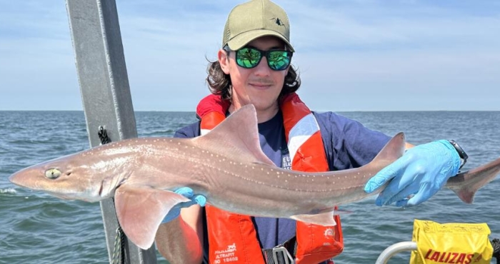
Tracking sharks in the North Sea for better protection and management
With support from LifeWatch Belgium and the European Tracking Network (ETN), researchers are tagging sharks in the Belgian part of the North Sea to uncover their movements and preferred habitats. Scientists from the Flanders Marine Institute (VLIZ) and the Research Institute for Agriculture, Fisheries and Food (ILVO) lead this work, using LifeWatch infrastructure to collect vital data that will help guide targeted protection and management. -
Fish Don’t Know Borders: Tracking Aquatic Life Across Europe 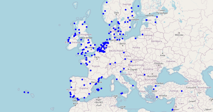
Fish Don’t Know Borders: Tracking Aquatic Life Across Europe
Through the European Tracking Network (ETN), LifeWatch Belgium connects researchers who track fish and other aquatic species across borders. Using a shared network of acoustic receivers, scientists follow animal movements from rivers to seas, revealing how aquatic life links ecosystems throughout Europe. -
From Europe to the Atlantic: new insights into eel migration 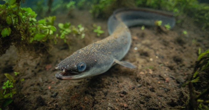
From Europe to the Atlantic: new insights into eel migration
European eels are legendary travelers, undertaking journeys of up to 9,000 km to spawn inthe Atlantic Ocean. A groundbreaking study led by LifeWatch researchers has broughttogether tracking data from more than 2,300 eels across 9 countries, revealing howgeography and river barriers shape the timing of this epic migration. -
SoundLib: The Marine Sound Library for the Belgian Part of the North Sea 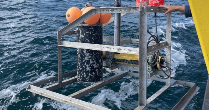
SoundLib: The Marine Sound Library for the Belgian Part of the North Sea
VLIZ has launched the Marine Sound Library (SoundLib), a unique open database of underwater sounds from the North Sea. With thousands of recordings and advanced analysis tools, the platform provides new insights into the region’s acoustic environment. SoundLib supports scientists, policymakers, and the public in understanding how natural and human-made sounds affect marine ecosystems, and creates new opportunities for AI-driven research. -
Waves of Resonance: An artistic journey with LifeWatch Belgium’s ocean data 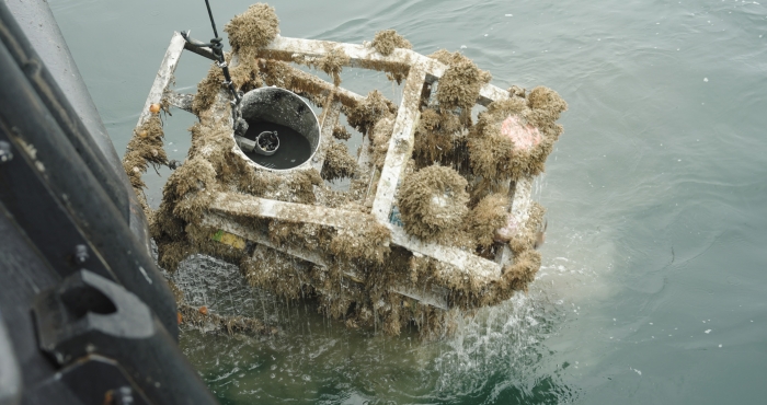
Waves of Resonance: An artistic journey with LifeWatch Belgium’s ocean data
Waves of Resonance is a sound project by artist Elise Guillaume, initiated during the European Marine Board’s EMBracing the Ocean artist-in-residence programme under the UN Decade of Ocean Science for Sustainable Development. She collaborated with Clea Parcerisas (LifeWatch Belgium) and Marine Severin (VLIZ) to explore the psychological impact of marine sounds. LifeWatch Belgium played a key role by providing unique underwater sound data from its observatory in the Belgian part of the North Sea. -
NELOS divers use WoRMS in digital dive log: a step toward citizen science 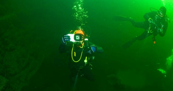
NELOS divers use WoRMS in digital dive log: a step toward citizen science
The Flemish diving federation NELOS vzw (Dutch-speaking League for Underwater Research and Sports) has recently integrated the World Register of Marine Species (WoRMS) into its internal platform DIVES — a Digital Verification System used to log tens of thousands of dives each year. -
Sevenfold increase in stinging weever fish observed by SeaWatch-B 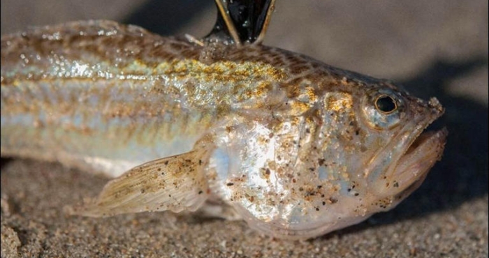
Sevenfold increase in stinging weever fish observed by SeaWatch-B
Between April and late June this year, weever fish counts were seven times higher than during the same period in 2024, according to SeaWatch-B, the citizen science project of the Flanders Marine Institute (VLIZ) under the LifeWatch Belgium Programme. -
Awardees for the 2025 WoRMS Achievement & Early Career Researcher Award known 
Awardees for the 2025 WoRMS Achievement & Early Career Researcher Award known
This year, Sammy De Grave has been honored with the WoRMS Achievement Award, and the WoRMS Early Career Researcher Award goes to Sávio Gabriel Gomes Pereira. -
Noise pollution in the North Sea 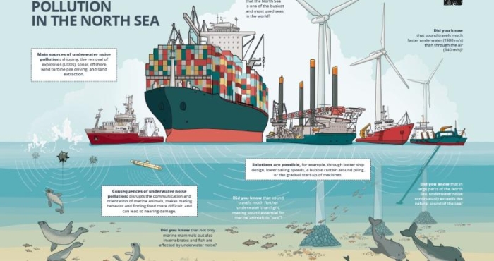
Noise pollution in the North Sea
The North Sea is one of the busiest seas in the world. All this human activity creates a lot of noise underwater. This can have harmful consequences for marine mammals and other organisms in our sea. Fortunately, measures exist to limit noise pollution. The Marine Environment Service (FOD Public Health) and DG Shipping (FOD Mobility), with the support of LifeWatch VLIZ, collaborated on a campaign to raise awareness about underwater noise pollution among the wider public.